HOTELS
APARTMENTS
CAMPING
AGROTOURISM ACCOMMODATION
Traveler's Guide
East Macedonia & Thrace
Route from Komotini to Polyanthos village, the medieval stone bridge in Kompsatos, Iasmo and Thracian Meteora - Rhodope Region
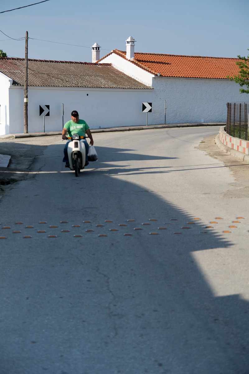 The route is interesting if it is done in May or June when cherries come. The villages west of Komotini situated at the foot of the Rhodope villages known as the "Giaka" it is produced one of the tastier varieties of cherries in Greece which is also being exported. Move north towards the village Symbola. After crossing the village on your right is a Macedonian tomb which you can visit only after consultation with the Archaeological Museum of Komotini.
Then come back and follow the signs to the villages Pholea, Dimi, Agiasma and Thamna. After Thamna and after passing the campus of Komotini, find the road to Misko village. At the 2.5 km you will find a sign for Maximianoupolis on your left. In the ruins of the Byzantine city later dubbed Mosynoupoli where there are the ruins of the Episcopal Church. Continuing the road to the south and acrossing the road of Komotini – Iasmos, turn right and after 9 km you will come across the village Polianthos. Drive through the village and follow the old road and the sign to the medieval bridge. Leave your car a few meters before the bridge. In two minutes you will see one of the best preserved stone bridges of Greece. The bridge is located at the exit of Kompsatos, which stems from the Rhodope mountain, crosses the Thracian valley and empties into Vistonida Lake. In the surrounding area have been identified several sites with pre-Christian and Christian antiquities main Byzantine castle Polyanthos and an aisled basilica church between the village and the bridge. The three-arched bridge was with two piers and two abutments and its direction is from West to East.
Today survives the middle and eastern arc and the eastern abutment. The middle arc was raised slightly larger. Its opening is 21.80 m long and has a height of 12 meters. The arc in east has an opening of 17 m. On two piers there are reliever’s openings with flat base and arched roof. It is considered to be a work of craftsmen from Epirus and it dates back to 17th-18th century.
Continue to Iasmos the capital of the municipality that has as its emblem a bridge. Iasmos is an old and rich village throughout the centuries, with a rich tradition offers you the opportunity to rest and try local and European cuisine with stunning views over the valley and the Vistonida Lake. Make sure you have fuel and car charger for your cell phone.
Continue after Iasmos to Xanthi in one kilometer you will find signs right to the Thracian Meteora. From here it begins a rough dirt road of 25 km length. 9km after Iasmos turn left to Polyarno and Euthimo.
After Polyarno you will find signs with two alternative routes marked hiking trails that will lead you to the Thracian Meteora, with their geological formations that will amaze you. If you are lucky you may come across herds of wild horses.
On the way there are several signs that will facilitate you. Turn to Iasmos. If you wish in Polyarno there is a hostel. For the keys please contact the Municipality of Iasmos. Onsite services are not offered.
Finally, taking the Egnatia Highway you can return to Komotini in just ten minutes. (Total distance covered 58+45 Km, duration 4 hours)
The route is interesting if it is done in May or June when cherries come. The villages west of Komotini situated at the foot of the Rhodope villages known as the "Giaka" it is produced one of the tastier varieties of cherries in Greece which is also being exported. Move north towards the village Symbola. After crossing the village on your right is a Macedonian tomb which you can visit only after consultation with the Archaeological Museum of Komotini.
Then come back and follow the signs to the villages Pholea, Dimi, Agiasma and Thamna. After Thamna and after passing the campus of Komotini, find the road to Misko village. At the 2.5 km you will find a sign for Maximianoupolis on your left. In the ruins of the Byzantine city later dubbed Mosynoupoli where there are the ruins of the Episcopal Church. Continuing the road to the south and acrossing the road of Komotini – Iasmos, turn right and after 9 km you will come across the village Polianthos. Drive through the village and follow the old road and the sign to the medieval bridge. Leave your car a few meters before the bridge. In two minutes you will see one of the best preserved stone bridges of Greece. The bridge is located at the exit of Kompsatos, which stems from the Rhodope mountain, crosses the Thracian valley and empties into Vistonida Lake. In the surrounding area have been identified several sites with pre-Christian and Christian antiquities main Byzantine castle Polyanthos and an aisled basilica church between the village and the bridge. The three-arched bridge was with two piers and two abutments and its direction is from West to East.
Today survives the middle and eastern arc and the eastern abutment. The middle arc was raised slightly larger. Its opening is 21.80 m long and has a height of 12 meters. The arc in east has an opening of 17 m. On two piers there are reliever’s openings with flat base and arched roof. It is considered to be a work of craftsmen from Epirus and it dates back to 17th-18th century.
Continue to Iasmos the capital of the municipality that has as its emblem a bridge. Iasmos is an old and rich village throughout the centuries, with a rich tradition offers you the opportunity to rest and try local and European cuisine with stunning views over the valley and the Vistonida Lake. Make sure you have fuel and car charger for your cell phone.
Continue after Iasmos to Xanthi in one kilometer you will find signs right to the Thracian Meteora. From here it begins a rough dirt road of 25 km length. 9km after Iasmos turn left to Polyarno and Euthimo.
After Polyarno you will find signs with two alternative routes marked hiking trails that will lead you to the Thracian Meteora, with their geological formations that will amaze you. If you are lucky you may come across herds of wild horses.
On the way there are several signs that will facilitate you. Turn to Iasmos. If you wish in Polyarno there is a hostel. For the keys please contact the Municipality of Iasmos. Onsite services are not offered.
Finally, taking the Egnatia Highway you can return to Komotini in just ten minutes. (Total distance covered 58+45 Km, duration 4 hours)


- [Home][CULTURE][RELIGION]
- [NATURE]
- BEACHES
- FORESTS
- WILDLIFE SHELTERS
- CANYONS
- RIVERS
- CAVES
- NATURA
- LAKES
- WATERFALLS
- HOT SPRINGS
- MOUNTAINS
- PARKS
- AGROTOURISM
- ALTERNATIVE
- MUSEUMS
- SIGHTS
- [CONFERENCE ][ACTIVITIES][INFORMATION]
- [ΑCCOMMODATION][FOOD AND DRINK][ΤOURIST SERVICES]
- [POINTS OF INFORMATION][HEALTH][COMMERCE]
- [ENTERTAINMENT]
Privacy Policy
×
News
Contact
Copyright©2025. All rights reserved.
Privacy Policy
Intellectual and Industrial Property Rights - Responsibility of the Site and the Region of East Macedonia & Thrace
The content of this portal has been collected and evaluated by each partner of the project (Region of East Macedonia & Thrace, Regional Administration of Smolyan, Regional administration of Kardzhali και Regional Administration of Haskovo) for the area which each partner represents. Each partner represents each region for the implementation of the Action 3.2 "Content Collection" for the approved applitcation form of JTI - TARGET project under "Greece - Bulgaria 2007 -2013" Interreg Call. The content including images, photos, graphics, texts, textures and in general all the data of the portal is in the responsibility of each partner. The content update and upload of each region belongs to each partner which has also the copyright for those content. This means that the content in this portal of all the point of interests of the Region of Smolyan belongs to the Partner Regional Administration of Smolyan. The content in this portal of all the point of interests of the Region of Haskovo belongs to the Partner Regional Administration of Haskovo, The content in this portal of all the point of interests of the Region of Kardzhali belongs to the Partner Regional Administration of Kardzhali, The content in this portal of all the point of interests of the Region of Region of East Macedonia & Thrace belongs to the Partner Region of East Macedonia & Thrace.
Given the nature and the size of the Internet, under no circumstances, including the case of negligence, will the Region of East Macedonia & Thrace is not responsible for any kind of loss caused to the visitor/user of the pages, services, choices and contents of this portal, which one undertakes at one’s own initiative. The portal and the Region of East Macedonia & Thrace do not guarantee that the pages, the services, the choices and the contents will be provided non-stop and without errors and that the errors will be corrected, because each content belongs to the Region that belongs. Furthermore, the portal and the Region of East Macedonia & Thrace do not guarantee that the servers, through which it is made available to users, do not contain “viruses” or other harmful contents. The Region of East Macedonia & Thrace guarantee the correctness, completeness or even the availability of the contents, pages, services, choices or their results only for its Region, not for the other Regions.
Links to other Websites
The Portal and the Region of East Macedonia & Thrace do not control the availability, the content, the personal data protection policy, the quality and the completeness of the services of other web sites and pages to which it directs users through hyperlinks. Consequently, for any problem arising during their visit/use, the user has to address directly the corresponding web sites and pages, which have the full responsibility for the delivery of their services. The Portal and the Region of East Macedonia & Thrace can under no circumstances be considered to agree with or accept the content or the services of the web sites and the pages to which it directs users or to be associated with them in any way.
Applicable Law and other Conditions
The aforementioned terms and conditions of the use of the Portal, as well as any modification of them, are governed and completed by the Greek law, the law of the European Union and the relevant international treaties (like indicatively and not restrictively the Law 2472/1997 for the protection of the individual and the protection of personal data, as completed by the decisions of the Chairman of the Committee for the Protection of Personal Data, the Presidential Decrees 207/1998 and 79/2000 and Article 8 of the Law 2819/2000, as well as the Law 2774/1999 and the European Law (directives 95/46/EC and 97/66/EC). Any provision of the above conditions that becomes opposing to the law, it ceases to apply by right and is removed from the present, without the validity of the remaining conditions being affected in any case. No modification of these conditions will be taken into account and will be part of this agreement, unless it has been officially formulated and incorporated into it.
Contractors: DOTSOFT AE & IKNOWHOW AE
