Traveler's Guide
East Macedonia & Thrace
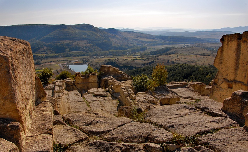
Archaeological Complex "Perperikon"
Perperikon is located on a high peak in an area known locally as Gin Tepesi ( The Mountain of the Spirits).
Dating from the time of the Roman Empire, archaeologists have uncovered a giant multi-story palace and an imposing fortress built around the hill, with walls as thick as 2.8 m.Temples and quarters of residential buildings were also constructed in the fortress. The megalithic complex had been laid in ruins and reerected many times in history.
The earliest traces of human activity are from the late Stone-Copper Age (Chalcolithic) at the end of the fourth century BC, when people began to worship and bring gifts to the Rock (so-called megalithic culture). The main findings from the Copper Age have been found in a cleft and several pits which had been roughly hewn into the rocks. Pieces of pottery, painted with red paste and decorated with incised lines, were found. Other pieces are graphite-decorated, which was more typical of the period. Other unique items, such as fragments of cult tables, were made of clay. Parts of idols, and a bowl in the form of a partridge, were also among the finds. Apparently, hallucinatory drugs for the priests were stored in bowls such as this. From the Chalcolithic period, there are several great knives formed out of flint, one of which is 20 cm long. Experts say this material can only be found in modern northeastern Bulgaria, where it was introduced as an expensive commodity. It may have been exchanged for gold nuggets, in which the Eastern Rhodopes are rich. The collection of 15 cult triangular darts from semiprecious stones with very small dimensions is also unique, as are the two "kalapesti" axes, with perfectly polished sides.
The development of the rock complex continued during the Bronze and Iron Age. There is solid evidence it was during the Late Bronze Age (16th -11th century BC) when Perperikon experienced its first big boom. This is the era of the Crete-Mycenaean civilization. Extremely interesting is the discovery of late Bronze Age pottery, represented by numerous fragments and some precious bowls. Some are small cups, while others are tall, curved handles, typical of the time. The ceramic decoration follows the decorative technique of the time called "furhenshtih" - incising of beautiful images in the bowl and filling in the contours with white paint. Among those images are depictions of the Sun and its symbols such as five-pointed stars, swastikas and others. Excavation also revealed fragments of imported pottery from the coast of the Marmara Sea, which are dated back to 18th BC, and demonstrate one of the first manifestations of the main sign of human civilization - trade.
A special interest arouses a unique fragment of a stone inscription on which survived three characters of Linear A used in the central-southern region of Crete. This is one of the oldest human writings used in the Mediterranean during the 15th -14th century BC. It can be sounded out, but the meaning of language cannot be understood. Until recently it was thought that Linear A was used exclusively in Crete and the surrounding islands. The excavated inscription in Perperikon raises the question of closer ties between the sacred place and the great Mycenaean or Minoan civilization.
The powerful development of cult facilities on the hill during the Late Bronze and Early Iron Age turn Perperikon into a spectacular sanctuary. Because of the finds, researchers hypothesize that Perperikon was the antique place god Dionysus made his prophecies about the future.
The Greek historian Herodotus tells us about The Rhodope shrine. He describes the march of the Persian king Xerxes against Greece in the 5th century BC. Somewhere in the Aegean Sea, between today"s cities Aleksondropulis and Kavala, the Persian ruler established a camp and started to welcome numerous envoys from the Thracian tribes inhabiting the interior. The satri envoys from the Sacred Rhodope Mountains were the only ones who never showed up. They were the most freedom-loving Thracian people and would never accept foreign power. They were the mountaineers who maintained the famous temple of god Dionysus. Their priests were the Bessi (later this name was used for all Satri) and they guarded the sanctuary. An oracle lived in it and the predictions she made were not very different from those of the famous priestess living in the Apollo temple at Delphi.
The second evidence comes from the Roman historian Suetonius. He tells of an expedition of the father of the first Roman emperor Augustus (63BC-14AD) The commander visited the famous shrine of Dionysus when he was on a war mission somewhere in old Thrace. Suetonius does not specify the location, but he gives a more accurate description of the ritual. Wine was emptied on a large round altar first, and then fire flared, the height of which predicted the future.The Roman author Macrobius does specify that the altar was located in a large oval room. This was called wine-fire ceremony, witnessed in other temples of god Dionysus as well. Suetonius continues that the father of Augustus received prophecy that his son would conquer the world. The same prophecy had previously received only one man - Alexander the Great when he was on the way to conquer Asia.
Another Roman historian Dio Cassius, tells about the march of captain Marcus Licinius Crassus in 29-28 BC. Already personally sent by Augustus himself, he took the temple of Dionysus away from the Bessi and gave it to another Thracian tribe -the Odrisses.A war for the sanctuary broke out between two large Thracian people in 11 BC. This information is important evidence for the location of the sanctuary of Perperikon, because it is known that the border between the Bessi and Odrisses ran somewhere east of present-day Kardzhali .
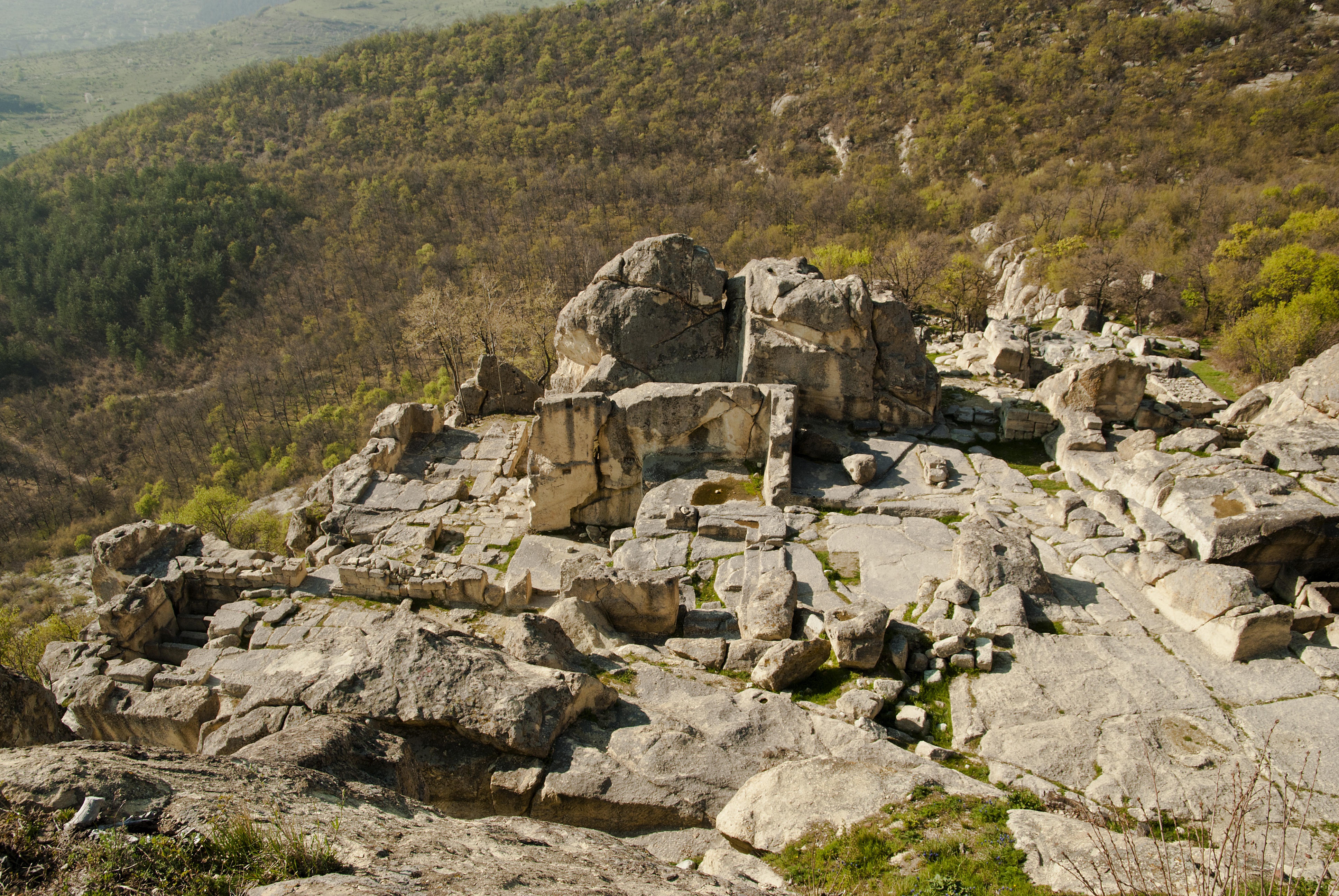
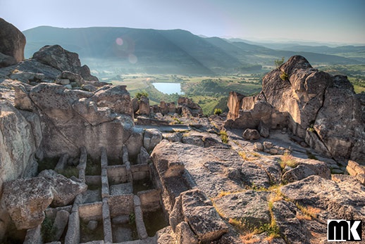
One discovery falls in line with the description of the famous shrine. A huge hall was revealed in the northwestern part of Perperikon. The room is oval with a diameter of about 25 m. The walls were roughly worked. In the center there is a magnificent carved round altar with a diameter of almost 2 meters. It rises to about 3 m above the floor. Numerous semicircular pits were found on its surface. They were carved into rock with crushed pottery and Roman coins from the 3rd -1st century BC. Northeast of the altar, there is an almost square platform, again carved into the rock and used for the cult acts of the priests. To reach this cult facility it took a 100-meter rock-cut passageway. This was a classic "road to the temple," leading to the palace from the southern slope of the hill. The width of the passage is 3-4 m and the height of the side rocks in places reaches 7-8 m.
The whole area of Perperikon is covered with rock cuts in the form of synclines with carved holes, which are channels for draining fluid. These are called "sharapana" and are presses for draining grape juice for the production of ritual, sacred wine. The very making of wine is also associated with the cult of Dionysus.
During the so-called Hellenistic era (4th –1st century BC) religious activities on the hill considerably decreased and life almost died out.
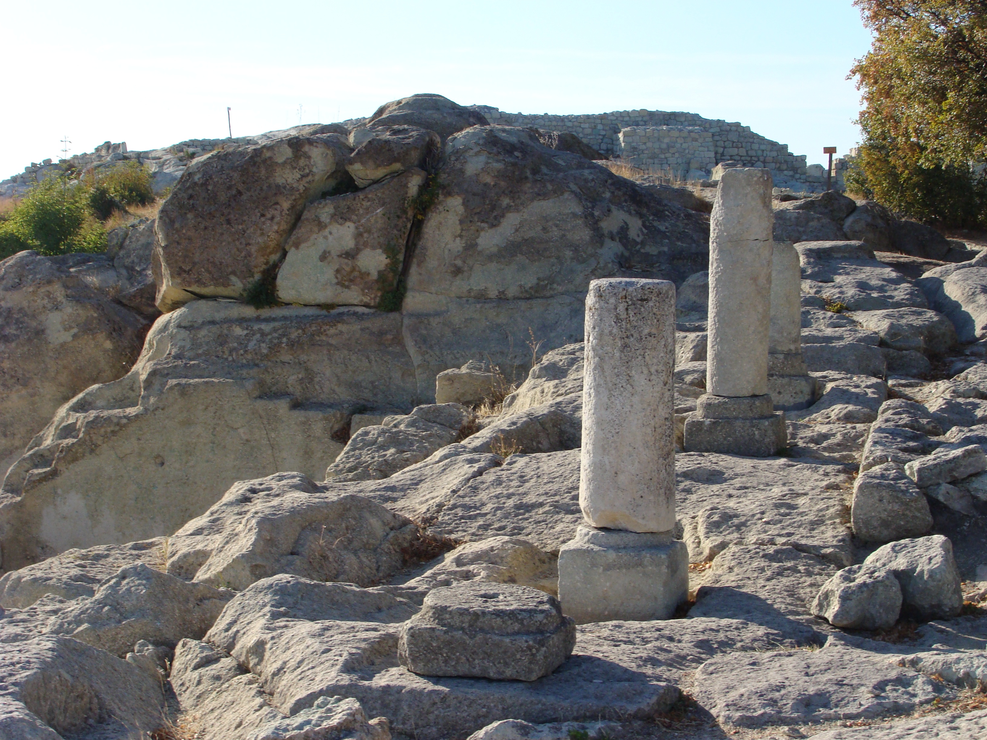
In 45 A.C. all of Thrace was conquered by the Roman Empire. A powerful process of Romanization began. Perperikon didn"t stay away from the process. In the 1st- 4th centuries, the rock-hewn facilities acquired a finished, classical appearance. The rock crown was protected by a powerful fortress - Acropolis, whose walls are 2.8 m thick. It is most likely that the fortress was built in the early periods, but was revived and further strengthened during the Roman era. Both walls of the fortress were formed by massive stone blocks with a perfectly carved front. Between the two rows of blocks there is rubble, which sealed the interior perfectly.
Two of the gates of the Acropolis have been studied so far, but there must have been at least two more.The South Gate,which was constructed in the Late Bronze Age, is particularly interesting. It was originally carved into the rocks and it could be reached by rough stone steps. The walls were built up with massive limestone boulders, roughly fitted together with minimal clearance between adjacent stones and no use of mortar. This is called Cyclopean masonry.The South Gate was reconstructed several times in antiquity and the Middle Ages it was blocked with a wall and stopped functioning.
Large residential quarters with many temples and buildings developed on the south and north slopes of the hill.The ground floors of all the buildings were carved in the rocks.
The so called "Little Palace" is a rectangular complex. Its length is 28 meters while its width can not be calculated exactly. The palace has two ceremonial entrances - from the north and south.There are 17 premises inside. This could have been the palace of the Roman deputy assigned in charge of Perperikon by the Central Imperial power.
An important detail in the Palace is the 30-metre long Auditorium, located east of the courtyard. To the west it is entirely carved into the cliffs while to the east it continues on wooden beams supported by two massive walls. The entrance to the ceremonial hall was formed with a five-step staircase and a double door, watched over by the palace guards. Two crypts are open in the west and east parts of the palace, hidden deep beneath the surface of rocks. There are 15 sarcophagus in the first and 5 in the second, all formed of massive stone slabs. Unfortunately, the tombs were robbed in antiquity and who had been buried in them is a matter of mere speculation. It is important to note that the terms "palace" and "church" should not be opposed. It is known that the Thracian ruler was also the first priest in his country. His temple was where he resided.
On the north side of the courtyard there is a massive stone throne ,carved into the rock, with a step for the feet and armrests. The southwest presmises received the name " the bath" because shallow synclines, alternatating with benches, were carved in the stone. Particularly interesting is the bed shaped for a huge reel in the basement under the ceremony hall. It may well have been a lifting mechanism for the ascent of food and other items.
In 378, the tribe of the Goths invaded the Balkan borders of Byzantium and Thrace was laid bare along with the whole Rhodope area. Perperikon was also conquered and burned in these troubled times. Part of the fortifications were destroyed and many temples and buildings were burned. The city was restored in 5th -6th century and with the adoption of Christianity,churches appeared on the hill. An important finding from this period is a magnificent single nave basilica situated near the main reservoir at the top of the hill. It is 17 m long and was built of well-worked stone blocks. Originally the floor was covered with massive stone slabs. At the altar the so called sintron seats were preserved, the seats where the senior clergy sat during liturgy. A magnificent episcopal pulpit has been found- the pulpit where arhierite delivered their sermons.It is almost untouched by time and richly decorated with stone-carved ornaments. An eagle with widespread wings is clearly seen on the rock. It also bears five inscriptions in Greek, which are yet to be explained but which archaeologists suppose are liturgical writings.
There is a hypothesis that the christianising of the Rhodope population starts from Perperikon. It was done by Nickita Remesianski in 393-398 . If this is true, it must also be true that the sacred books were translated into the language of the Bessi, in order to accept the new faith more easily. Translation most likely occurred in the complex of buildings near the basilica.
Toward the begining of the 7th century Perperikon was almost abandoned. Certain excavated paintings with a religious character are related to this period - a symbolic game of "lady" and a ritual display of female genitalia. The latter are probably associated with the image of the Turkic fertility goddess Umai. These drawings are related to the chief of prabalgari, Kuber.
An upsurge in architecture, art, etc is observed in the Byzantine Empire, and in Perperikon in the 9th century.
The fortress of Perperikon increased in importance again in the 7th -14th century when the new administrative unit Achridos was created. For a short period of time, an extremely intensive construction and reconstruction of old cities took place, which formed Achridos infrastructure. The Byzantine name of Perperikon was Hyperperakion.
Perperikon"s importance considerably rose in the 13th -14th century. In 1339, in a letter of the Ecumenical Patriarchate, it was designated as an episcopal center, clearly separated from the old Achridos department. The riches of Perperikon caused frequent collisions between Bulgaria and Byzantium, which were constantly competing for the Eastern Rhodopes. During the reign of the kings Kaloyan and Ivan Asen II, the territory was within the Bulgarian state, but their heirs lost it. In 1254, Tsar Michael Asen attempted to regain Achridos. He conquered Perperikon and other cities, but the siege of the fortress ended without success and the Bulgarians withdrew.
Excavation shows that during the the 12th -14th century life in Perperikon was intense, but lacked the glamor of antiquity. Above the ruins of the late ancient temple, in the eastern part of the rock, a new church was built, now entirely built of crushed stones, fitted together with strong white mortar. Its dimensions are quite modest - 6.5 to 3.6 m.It is a one nave church.There is a large necropolis nearby that gives an idea of the population size.Many ceramic objects and coins have been found. Especially interesting are the extremely rare for this area silver coins of king Alexander, which register his short-lived authority in Perperikon.
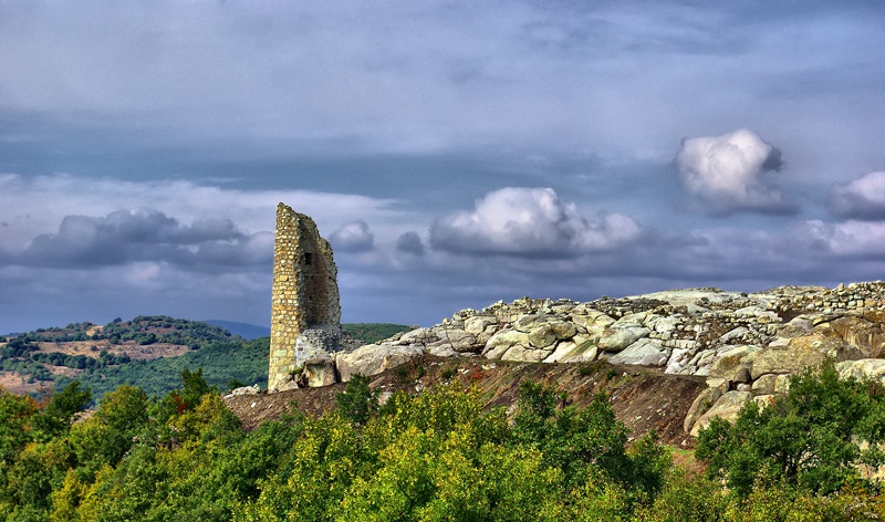
Another fortress was built in this period. At the highest end of the reservoir, a powerful citadel was constructed.It was intended as a last resort place during siege. It was entered from the east gate, which was flanked by two rectangular towers. Main was a massive octahedral tower by the old West gate, erected after the end of the 12th century. The tower is hollow and had several stories. The Fortification is preserved well and reaches a height of 7 to 8 m. The tower must have been a self defense unit – i.e. a donjon, where they sheltered the surviving defenders when the main fortress was captured.
The Citadel was not able to save the local population in the second half of the 14th century when the Ottoman Turks invaded the Balkans. First fell the main fortress, so the defenders locked behind the strong walls of the citadel.The fierce battles have left hundreds of arrowheads, spears, maces, fragments of broken swords and scimitars. After the Turks captured the fortress, they stationed a garrison for some time. There are many silver Ottoman coins which do not exceed chronologically the last decades of the 14th century. The fortress was needed to organize attacks against the north and northeast Bulgarian cities. After their capture, the fortress was no longer needed and it was abandoned. Life in the ancient city has never revived ever since, but a few small settlements have grown up at its foot.
Address
No information available.Contact Information
No information available.
Related


- [Home][CULTURE][RELIGION]
- [NATURE]
- BEACHES
- FORESTS
- WILDLIFE SHELTERS
- CANYONS
- RIVERS
- CAVES
- NATURA
- LAKES
- WATERFALLS
- HOT SPRINGS
- MOUNTAINS
- PARKS
- AGROTOURISM
- ALTERNATIVE
- MUSEUMS
- SIGHTS
- [CONFERENCE ][ACTIVITIES][INFORMATION]
- [ΑCCOMMODATION][FOOD AND DRINK][ΤOURIST SERVICES]
- [POINTS OF INFORMATION][HEALTH][COMMERCE]
- [ENTERTAINMENT]
Privacy Policy
Intellectual and Industrial Property Rights - Responsibility of the Site and the Region of East Macedonia & Thrace
The content of this portal has been collected and evaluated by each partner of the project (Region of East Macedonia & Thrace, Regional Administration of Smolyan, Regional administration of Kardzhali και Regional Administration of Haskovo) for the area which each partner represents. Each partner represents each region for the implementation of the Action 3.2 "Content Collection" for the approved applitcation form of JTI - TARGET project under "Greece - Bulgaria 2007 -2013" Interreg Call. The content including images, photos, graphics, texts, textures and in general all the data of the portal is in the responsibility of each partner. The content update and upload of each region belongs to each partner which has also the copyright for those content. This means that the content in this portal of all the point of interests of the Region of Smolyan belongs to the Partner Regional Administration of Smolyan. The content in this portal of all the point of interests of the Region of Haskovo belongs to the Partner Regional Administration of Haskovo, The content in this portal of all the point of interests of the Region of Kardzhali belongs to the Partner Regional Administration of Kardzhali, The content in this portal of all the point of interests of the Region of Region of East Macedonia & Thrace belongs to the Partner Region of East Macedonia & Thrace.
Given the nature and the size of the Internet, under no circumstances, including the case of negligence, will the Region of East Macedonia & Thrace is not responsible for any kind of loss caused to the visitor/user of the pages, services, choices and contents of this portal, which one undertakes at one’s own initiative. The portal and the Region of East Macedonia & Thrace do not guarantee that the pages, the services, the choices and the contents will be provided non-stop and without errors and that the errors will be corrected, because each content belongs to the Region that belongs. Furthermore, the portal and the Region of East Macedonia & Thrace do not guarantee that the servers, through which it is made available to users, do not contain “viruses” or other harmful contents. The Region of East Macedonia & Thrace guarantee the correctness, completeness or even the availability of the contents, pages, services, choices or their results only for its Region, not for the other Regions.
Links to other Websites
The Portal and the Region of East Macedonia & Thrace do not control the availability, the content, the personal data protection policy, the quality and the completeness of the services of other web sites and pages to which it directs users through hyperlinks. Consequently, for any problem arising during their visit/use, the user has to address directly the corresponding web sites and pages, which have the full responsibility for the delivery of their services. The Portal and the Region of East Macedonia & Thrace can under no circumstances be considered to agree with or accept the content or the services of the web sites and the pages to which it directs users or to be associated with them in any way.
Applicable Law and other Conditions
The aforementioned terms and conditions of the use of the Portal, as well as any modification of them, are governed and completed by the Greek law, the law of the European Union and the relevant international treaties (like indicatively and not restrictively the Law 2472/1997 for the protection of the individual and the protection of personal data, as completed by the decisions of the Chairman of the Committee for the Protection of Personal Data, the Presidential Decrees 207/1998 and 79/2000 and Article 8 of the Law 2819/2000, as well as the Law 2774/1999 and the European Law (directives 95/46/EC and 97/66/EC). Any provision of the above conditions that becomes opposing to the law, it ceases to apply by right and is removed from the present, without the validity of the remaining conditions being affected in any case. No modification of these conditions will be taken into account and will be part of this agreement, unless it has been officially formulated and incorporated into it.
